On the road in Patagonia
Note: For the start of this trip in Brazil and Buenos Aires, see the preceding post (“From Maranhao to Buenos Aires…”)
Barriloche is the ski resort of Argentina. It is so populated by snow-hungry foreigners that locals sometimes jokingly refer to it as “Braziloche.” It is a diverse city overlooking a beautiful lake, but it is also a busy place with hordes of visitors, young people and a mix of tourists and a somewhat normal economy for residents. This was the beginning of the trip that later led to mountain lakes and glaciers, and a Disney-like fantasy forest of eucalyptus trees.
 Barriloche has some odd sights along the tourist streets, like this tree with a bright crocheted cover. It may be an ad for local crafts, but it is nevertheless striking for visitors who may not have thought of dressing up a city tree this way.
Barriloche can be a destination for skiers and other outdoor sports, but the hardier travelers can take a bus that takes you south along endless miles of Patagonia. We went with Chalten Travel, the only compay we found that organizes a bus trip down Route 40
This waterfall is not far from one of the towns where we stayed.

 This region has remarkably the elegant lupins that rival the fields of lupins in the southwest England meadowlands. They are everywhere — in pinks, blues, and creamy whites.
Getting to them is not hard — they are all over — but driving deeper into Patagonia from Barriloche opens up endless skies, hundreds of miles, and lupin fields beneath mountain ranges.


One appealing trip from Barriloche is a boat trip to Isla Victoria and the Arrayanes eucalyptus forest on Lake Nahuel Huapi. The island itself was an experiment in forestry and the cultivation of begun in 1902 (my guess is that the island was named in honor of Queen Victoria who died that year).
California redwoods, midwestern U.S. pines, and dozens of species of trees and plants were cultivated there, apparently to create an economically active horticulture. The fruit trees didn’t survive, but many species of trees did. There are huge pine forests — non-native trees that are slowly being cut down and replaced with indigenous trees. There are California redwoods, apparently planted as a wood crop. The early cultivators seemed unaware that once a giant sequoia is planted you must wait a couple of hundred years to harvest it. At the time of our visit the redwoods were only a little over 100 years old and still a bit scrawny.
Isla Victoria is also the site of a forestry training camp and horticultural station where there is an active program of reforesting the island with native species. Foreigners can volunteer to spend a summer there.

From Barriloche you can also reach the Lake Viedma glacier by bus. It was our first glacier, and our first condor.

This isn’t very a very convincing picture, but I forgot to take my condor lens. We had seen a magnificent Andean condor in the Buenos Aires zoo, but we saw this one in flight above the Lake Viedma glacier. For a closer view, the photo below is the captive bird in Buenos Aires. It is hard to describe the size of these birds, but you might imagine a really large turkey — plump it up in your imagination to about 30 pounds and add nine or ten feet of wing span (there is also a Californian condor that is a bit bigger).
 This is an Andean condor in captivity in the Buenos Aires zoo. I prefer the free-range condor above, but this will give an idea of the size and beauty of the bird

The Arrayanes forest is a rare and exotic eucalyptus grove that allegedly served as inspiration for a Walt Disney movie. That perhaps apocryphal story is memorialized in the name of the “Bambi” tea house at the edge of the forest.

Cerro Tronador and the glacier
 On the way to Cerro Tronador: This photo is simply to show that we were some 41 degrees south — about as far south of the equator as Chicago is north of the equator. This was a long way from home, but not quite at the end of South America.
Much of the time you are in national parks like the one in the sign below.

Cerro Tronador, the volcano and the glacier
By local accounts, the glacier has receded tremendously in recent decades. From the promontory we can see the dark edge of the “black” glacier front. Further up the mountain is the white ice of the glacier. It is early in the season and there has not been new snow yet. Guides in the region say that the place where we were standing was under glacial ice in the 1960s. What we see here, as impressive as it may be, is only a remnant of the old glacial field.


 Not too encouragingly, the ascent to El Tronador, the volcano at the top of the glacier, is called “Garganta del Diablo,” “throat of the devil.”
We didn’t make it all the way into the devil’s mouth, but there was a beautiful mountain stream and view of the mountain range above.
Deeper into Patagonia
It is a long bus ride — actually several 12-hour rides, interrupted by stops in Perito Mereno, Chalten, and El Calafate. The view of vast open spaces is broken up by occasional bad roads, warning signs, scatterings of wild horses, occasional sheep and cattle ranches, and — most beautiful of all — wild guanacos on the range.
Guanacos are larger than deer and seem more powerful in the haunches. We would see them in small herds of 5-10 grazing and running on the endless ranges. The skies, too, seem to go on forever.


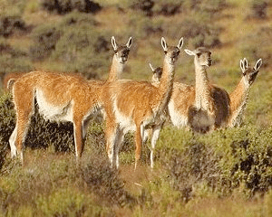 The guanacos we saw from the bus were either far away, moving quickly, or not patient enough to wait for me to find my camera, so these images are from online photos.
The animals they show are just like the lone animals and small groups we saw all across Patagonia.
 We know that they were a source of food and leather for the early nomadic peoples who decorated the “Cave of the Hands” milenia ago. Guanacos continue to survive on the steppes of Patagonia, sharing the vast spaces with wild horses, and with sheep and cattle in the scattered places where there is enough water and grazing. They have some resemblance to llamas and alpacas, but are a different species.
The buses would stop about every four hours for a driver change. It was a long four hours sometimes, since the on-board toilets generally had out-of-order signs on them. The stops are unpretentious but welcome.
In this region the towns are small and widely separated, and not quite ready for a bus full of hungry, sleepy travelers. This is one of the rare daylight stops. Most stops were actually dark, surreal interludes in a long ride through rain, mixed roads, and vast spaces of land and horizon. (The actual rest stop is “pizza” place behind me, but the Codfileria here seemed more inviting.)

Puerto Moreno and the Cave of the Hands


The goal of the tranquilita path down the mountain was the Cave of the Hands (Cueva de los Manos). It is named for the “stencils” or negative images made on the walls by nomadic peoples who used this rock face for shelter. The prints are made with mineral matter and have resisted fading or deterioration over what (the guides, and presumably the archaeologists say) has been 9000 and more years. Artifacts in the caves indicate that they lived in part from guanacos and various smaller animals in the valley. Because of the vagaries of rainfall in this region, they are believed to have been nomadic.

To Chalten and on to El Calafate
 This road sign for bemused travelers is a reminder that we are a long way from home. New York is more than 11,000 kilometers away.
That is probably about the same as the distance to Oshkosh or Kalamazoo or Petaluma, though they don’t mention it on the sign.

Our third glacier (Perito Moreno, near El Calafate)


