In March 2016 we visited Baekseok University in Cheonan City, in northern South Chungcheong province, South Korea. Simone Ferro taught dance and Laban Movement classes, Meredith Watts photographed.
These images are of Korean dance students in a Laban class.
Frankfurt was our first European layover after leaving Brazil. We only stayed about three days, enough to begin accustoming ourselves to 5-15 degree (Celsius) temperatures (after leaving São Luis at about 30 degrees and São Paulo at about 25.
This meant buying a jacket and a warm hat.
It was also a time to visit family and friends, and a few museums, around Frankfurt/Hessen.
Wiesbaden is a former aristocratic spa that was spared in World War because the American military wanted it as a headquarters. The American presence is reduced now, and the city has a charm and commercial/artistic character of its own.
Below is a figure commemorating the German unification. The meaning of the green man is a bit unclear to the casual visitor, but he is a symbol nonetheless. In the background of the photo is an old hotel that has been refunctioned into apartments. We stayed in a dear friend’s place there, looking down on the green man.
A statue commemorating German unification.
This is another view of Kranzplatz and the hotel. It shows why the “bad” (bath) in Wiesbaden. Beneath the city are hot mineral springs that have for centuries been used as thermal baths and spas. This mineral fountain bubbles constantly in the cool March air, giving off a faint smell of rotten eggs. Nearby there is a bulletin posting the mineral content and offering a drinking fountain of the water.
Below is an example of Wiesbaden functional public art. It decorates one wall of a playground and park that is usually filled with children, families, and a multicultural mix of Germans and immigrants.
Wiesbaden park/playground, Kranzplatz.
Below is the Russian-Orthodox Church, also known locally as the “Griechische Kapelle.” Above the city of Wiesbaden, it looks down into a valley through surrounding forests. Many visitors mention feeling a sense of meditative calm when they visit the church, as did we.
The church was built by architect Philip Hoffman for Duke Adolf von Nassau to commemorate the early death of his wife, a 19-year old Russian princess. It was dedicated in 1853 and has been maintained since as a center for worship of an active orthodox community in Wiesbaden and Hessen.
Wiesbaden offers a spa, a casino, opera, and ballet — and the world’s largest cuckoo clock (really!). But for many visitors the “Greek Chapel” is the most beautiful and culturally interesting of the city’s sites.
The Russian Orthodox chapel (known locally as the Griechische Kapelle), a famous landmark in the Taunus mountains above the center of Wiesbaden.
The Frankfurt Museum of Modern Art
For the serious visitor, there is a multi-card available at the visitor’s office on the Römerplatz (next to the city hall). The card offers discounts on multiple museum visits in a day. We visited the Miró exhibit at the Schirn Gallerie and the Museum of Modern Art before the day ran out.
German museums have followed the international museum trend of allowing visitors to photograph works of art. Unfortunately I didn’t take photos of the Miró exhibit and found out only later that I might have. That exhibit highlighted the artist’s fascination with large works that simulated rural farm walls in their backgrounds. Most of the canvasses appeared to have been painted on farm walls. This was a perspective on the “materiality” of his works that I had not seen before.
Interior of Frankfurt Museum of Modern Art (1). There is also a museum (2), but this one is the premier building, worth visiting just for the architecture itself.
The lead exhibit in the Frankfurt Museum of Modern Art was curated by John Forsythe, the American choreographer who had just finished 25 years in Frankfurt. He curated an exhibition in which virtually all the pieces used the visitor as part of the installation.
Visitors entered the art installations, danced, swung from gymnastic rings, crawled into small spaces, struggled to enter doors, looked into rooms that seemed to house a sleeping or dead person, and so on.
In this piece, dance steps are given on the floor (an Arthur Murray-type fox trot I think). A museum attendant helped us figure out what to do.
In another era this might have been a number in a Fred Astaire-Ginger Rogers movie.
An installation in the Frankfurt Art Museum. Simone dances with a museum attendant.
This is probably self-explanatory, but I’m at a loss to explain why i liked it so much.
This exhibition has a title referring to a Chinese ghost descending a mountain. It appears static at first, but as you walk around the vases they uncover pictures together than unfold the story. It is a piece of work to enter and walk around many times.
From the photo you can probably see that the vases have different elements of the picture, allowing the story to unfold like an old-fashioned deck of pictures that show a moving scene when flipped. This is more meditative.
This is probably also self-explanatory, though why one stands so long looking at it is not clear to me (even as I did it). It is like the cover of a crime or mystery novel, but without having any story other than the one you bring to it.
These gymnastic rings in the photo below invite you to cross the room (which is itself the art work) on the rings. We didn’t see anybody do it. Most ended up hanging helplessly like this person. Maybe that is the point. It may be a meditation on humility.
In the photo below “Old Bridge” crosses the Main River from the area of the Römerplatz to the Museum Embankment (Museum Ufer) where there are a dozen or so museums, each worth a half day or more.
I’ve seen this custom of attaching locks to a bridge in Cologne near the art museum there, and I understand that is widely done throughout Europe. A common interpretation is that it ia done by couples to signify lasting love. There is even a story of a bridge in Paris where tons of locks were removed because they threatened the integrity of the bridge.
The custom reminds me of the light poles outside some museums where visitors stick their exposition stickers when they leave. Someday a cultural anthropologist will find this interesting and write a monograph about it.
Locks that may signify lasting love for the people who place them there.
The Main River from the “Alte Brücke” that leads pedestrians from the Römerplatz to the Museum Ufer where the far embankment of the Main houses a dozen or so museums. We are looking back at the Frankfurter Dom, he cathedral just to the left of center in the photo.
Northern Italy Between Venice and the Julian Alps: Udine, Tarvisio, Palmanova, Aquilaea, Vila Manin, Castelmonte, Gemona, Cividale, Venzone.
Within a few hours drive of Venice are vast regions of Roman cities and ruins, the base of the Italian army during World War I (close to the invading Austro-Hungarian border), regional villages, and the remnants of a major earthquake that changed the landscape and wiped out cities in 1976. A bit further to the north is the city of Trieste, which is treated in a separate blog.
Udine is the center of our trips here. Not as well known as Venice, it is a major regional city and former Roman outpost.
Tarvisio: From a cable car in the Julian Alps, just a few miles from the Slovenian and Austrian borders.
Tarvisio, Julian Alps: top of the mountain range
Tarvisio
Venzone, the “Lavender Shop.” The region is known for its lavender blossoms that are used for scents and practically everything else.
Venzone — a medieval village in Friuli that was rebuilt after the 1976 earthquake destroyed many towns in the region. The old city wall reconstructed.
The old square in Udine. It was a Roman outpost, later part of the Venice administration, now center of the region of Friuli.
Udine along the canal.
Believe it or not, a bathroom in the Udine modern art museum. It was built in a huge house bequeathed by a fabric merchant. This display is his actual bathroom, with undersized fixtures for his small stature. The shoe forms seem to be added to make this bathroom an artistic installation.
The eccentric dining hall of the fabric merchant’s bequest — the art is oversized, the furniture sized smaller for his proportions.
Steps from the old Udine center to the church/museum of traditional art.
From the top of the stairs, in front of the church/museum — looking out over the valley around Udine.
Vila Manin, residence of the last Doge of Venice and legendarily a short-term residence of Napoleon before his march on Europe.
The Vila Manin now houses a museum, here showing an exhibition of Mirós late works from his Mallorca period. This symbolically reconstructs one of his work spaces.
Vila in early evening with some blue left in the sky.
Aquilea — a major Roman outpost and shipping port. Now the whole city is a museum (you get an audio guide that literally takes you through the entire town). This is a mosaic preserved in the floor of the church of the patriarchate. Some parts of the church are about a thousand years old.
A marble statue in the church of the patriarchate.
Mosaic with a ram motif.
From the vast collection of Roman statuary in Aquilaea.
The Adriatic coast of Grado, Italy. A popular resort in season, but more pensive in March.
House in Grado, Italy
Wall of Miracles in Castelmonte. The pictures and other artifacts memorialize events in which it was believed that the Virgin Mary miraculously intervened.
Detail of one of the miracles. Unlike the Middle Ages where miracles were often associated with plague and war, these events are often associated with modern mishaps — here, a farm accident.
An old well and statues on the rest of Castelmonte, sunset
Arch in the mountain church of Castelmonte.
A pastel evening, just at dusk, from the Devil’s Bridge in Cividale.
In the mountains near Interneppo — an old watercourse leading from the mountains down into the valley.
Church in Gemona, at the epicenter of the 1976 earthquake. Much of the church was badly damaged. The off-kilter pillars (especially at the left) are not an effect of the camera lens — they were shifted in the earthquake and left off-center when the church was rebuilt.
This remainder of a crucifix from the earthquake has been especially set as a memorial to the disaster and the recovery.
As a frontier city between Italy and the regions of the Austro-Hungarian empire (now Slovenia and Austria), the city of Trieste is a fascinating mix of languages and cultures. It has four official languages — Italian, Slovenian, Friulian (Eastern Laldino) and German.
It has been occupied by the Romans, the Habsburgs, Mussolini’s Fascist regime, and a mixed regime of allied forces after World War II. It reverted to Italy in 1954 as the Allied occupation withdrew. Officially it is the capital of the autonomous region of Friuli Venezia Giulia.
It is located on the sea and is a major port. In the photo below the sea below has extensive oyster beds that seem to be tended by boats like the one below.
Not far from the view above is Miramar Castle which was built by Maximilian, brother of Ferdinand, Emperor of the Austro-Hungarian empire. He was commander of the navy and built this seaside complex as an appropriate residence for his status, interests in the sea, and culture.
It was completed in 1860, but he lived there only a few years before receiving an appointment as the Habsburg emperor of Mexico. He took the office n 1864 but it happened that the Mexicans did not want a European emperor. In the 1867 rebellion the regime was overthrown and Maximilian killed.
As it happens, I visited the ramparts of the castle in Mexico City where the resistance fighters made a stand and a number of cadets lost their lives in the fight. This was a major event in Mexican history, but in the slightly smarmy audio tour of Miramar there is scarcely mention of this (amid the lavish praise for his culture and lifestyle).
His wife Carla lived on for decades thereafter, but the empire in the New World was lost. The rest of the empire was lost and divided when the Habsburgs found themselves in World War I some some 50 years later.In fact as history buffs will remember, the triggering event of WWI was the assassination of the Habsburg Archduke Ferdinand in Sarajevo in 1914.
Maximilian’s Mexican empire was never fully established. It was not recognized by the U.S., was supported provisionally by French forces, and never conquered the resistance forces of Benito Juarez. After the American Civil War the United States supported Juarez more strongly, the French troops withdrew, and Maximilian was left exposed.
Miramar, last residence of Maximilian, younger brother of Emperor Franz Joseph.
Central staircase in Miramar, residence of Habsburg archduke Maximilian. He lived here from its completion in 1860 until his appointment as emperor of Mexico in 1864. The castle is a museum of the last days of the empire, both its culture and its distance from developments in Europe and the New World.
A well-known Trieste cafe/restaurant with Austrian-style dishes (e.g., diverse meats, horseradish, gallons of beer).
James Joyce lived in Trieste for about a dozen years after 1904. He is memorialized in this statue. Various sources delight in recounting which of his works were written or drafted here.
Historic buildings line the Trieste canal which leads from the center of town to the sea off to the right.
The central canal in Trieste, leading to the sea off to the right. At upper left is the Greek Orthodox Church, one of many religions represented in Trieste’s complex culture. One of Europe’s largest synagogues is also here in Trieste.
Waiting for coffee, these empire-style mirrors were irresistible.
Selfies…
Every Trieste cafe advertises itself as “classic” or “iconic.” Most do have good coffee and ambience.
Trieste’s central plaza (Piazza Unitá) is one of the largest in the world (in Trieste they maintain it is the largest, though why it should be so in a city of 200,000 is unclear). In March there is room for everybody to sit about undisturbed.
These photos are from a walkabout in Venice during March, 2016. We were with the Antonelli family from Udine and were guided by Erika Antonelli who lives and works in Venice. This local guidance from a dear friend is one reason that many photos are from small side streets in Venice, from the water canal and its commuter taxi, and from the train/auto terminal as you exit the city. We saw the major sights in the central plazas of the city, but it was a chilly day with construction going on and platforms everywhere to be erected if the water was high. Even the gondolas were more available and interesting because they were short of passengers and busied themselves with small chores, maintenance of the boats, or were simply happy to have us around. It was exactly the way I would like to see such a place — with a friend to guide us, a shortage of tourists due to the season, and plenty of time for lunch and a stroll.
On our way to a restaurant where Erika Antonelli works, we found this produce store, floating in the canal.
A floating fruit and vegetable market.
One of many quiet streets/canals with most tourists waiting for better weather.
In the smaller streets we spent time in the shops — well, some did, and except for the jewelry artisan (see photo below) stayed on the street to photograph.
The artisanal mask shops were especially fascinating (though some in our party liked the jewelry crafts better).
Venetian mask shop
The familiar masks below have many apocryphal origins — my favorite is that they were worn in during the plague by people who had to handle the sick, dying and the dead.
Some who saw the British production of “Sleep No More” would have put on masks like these to wander among the artists during the play.
Erika seemed to know this jewelry artisan who allowed me to photograph her at work inside her shop. The only time I entered a jewelry store.
A Venetian jewelry artisan.
Quiet streets and brooding skies. It was chilly ad the famous Venetian mosquitoes and tourist were scarce.
The gondoleer was less busy than during the tourist season and was here cleaning up his boat and the steps of his dock. It was curiously familiar to see the boatsmen as working people doing normal tasks, rather than just bearing up under an onslaught of tourist with little cameras, cell phones, and selfie sticks.
Between riders — which was a long time on this chilly March day — the gondoleer cleans up and does some maintenance of his dock and boat.
Even the ice cream shops were short of customers. It was too chilly for us too, and we opted for coffee along the way.
Another street/canal with boats at rest. I have been in Venice before, but never during such beautiful, lonely, and reflective time.
Gondolas at rest. Notice that they list to one side — this, we are told, is because the gondoleer stands slightly off-center and balances the boat.
A gondola marina with ship anchored in the harbor — under March skies.
This is Erika’s Antonelli’s finger pointing out the court on the left and the jail on the right. The walkway in the background shortens the time between sentencing and being herded off to the wet dungeons in the basement or the sun-baked cells above.
The short walk between the court and the dungeon.
The harborside walk is dotted with kiosks selling masks and Venetian tourist souvenirs.
The photo below is taken from a water taxi. Unlike the gondolas, which are picturesque and inefficient, the commuter taxis are power boats that dock periodically at quayside stops that are like subway stops in a landlocked city. The taxi takes you to the outer edge of the city where you can catch a train or pick up your car for the trip by land.
Early evening from a water taxi. The waterside villas and restaurants are beginning to put on their lights but the light has not quite gone out of the sky, leaving it a moody deep blue.
As our water taxi slowed to wend its way under the Rialto Bridge, this gondoleer passed us and the brightly-it dockside. Photographers will notice that he was kind enough to come by in HDR (the high-definition photographic technique used to bring out dark areas of a photo or film and sometimes produce surrealistic images).
The Rialto Bridge.
Below is one view of the terminal complex as you leave the city for land connections. The terminal and parking structure is in the background, the commuter trains in the lower section of the photo.
We arrived by car and train and left by water taxi and car. The commute takes some patience, as life on the water normally does.
Venice has its own Calatrava-designed bridge leading out of the city. It is a pedestrian bridge, elegant but still impassible for those with mobility limitations. It is slippery in the wet weather and altogether impractical, though elegant. Milwaukeeans may remember that Calatrava’s bridge from downtown to the Milwaukee Art Museum also had to be redesigned for safety and access.
The Calatrava bridge leading out of Venice. Its geometry is elegant and the footing uncertain in damp weather.
These photos are a small fraction of the images from our visit to Seoul and Cheanon, Korea in March, 2016. They are not thought of as a representation of Korea, but are simply some of the places we visited.
The goal of the trip was to spend a bit more than a week with the dance communities of Cheanon and Seoul, involving at least four universities that had dance programs. The time for actual touring and photographing was compressed and often done along the way to another commitment.
The dance photos will be the subject of another blog, but this is just a survey of some images from:
The “welcoming/farewell committee” for tourists at Incheon Airport
Scenes of the region’s urban density
A few peaceful places (a lovely lake, a reonstructed 17th century folklore village)
The Gakwonsa Buddhist temple complex near Cheanon
The imperial castle complex of the Joseon Empire, in the middle of Seoul (Gyeongbokgung Palace, established in the 14th century)
But first, to get this out of the way: The Koreans are not above entertaining visitors with costume melodrama at the Incheon Airport. We happened to be leaving Seoul when this procession came by.
They were actually a bit in the way as we struggled along with our luggage, but both western and Asian travelers lined up to take this picture. So did I, I’m afraid.
Welcoming/farewell committee at Incheon Airport, Seoul, Korea
In the region around Seoul there are cities, mountains, and very little “country.” There is agriculture in tiny plots all around the highways and urban spaces, but this is not the place for farms.
It is a place or urban high-tech consumption with shopping only hindered by the need for the newcomer to figure out what is behind the brilliant signs and lights.
This is along the main street of Cheanon, just at the entrance of a network of smaller commercial streets.
This area seems to have a 24-hour culture, with even Korean saunas staying up all night in some areas. You can spend the night there eating squid and baking under hot rocks or on beds of Himalayan salt.
Main street, Cheanon, Korea, at the entrance of a dense network of shops, all brightly lit for most of the night.
Along the main commercial street
Crossing from huge department stores to smaller shops in the inner commercial district. The crush of cars and public transportation is immense.
This is a pizza shop along one of the smaller commercial streets, with plastic sheeting against the March damp and chill.
Pizza shop, in the interior of the Cheanon shopping district.
The photo below is from the apartment in Cheanon where we stayed. The traffic is nearly constant, reminding me of the 24-hour traffic jams in São Paulo, except that here they (sometimes) move faster.
The lake at the right is dotted with several universities and schools, along with small agricultural plots in virtually every unbuilt space.
Traffic along the Seoul-Cheanon highway. The lake on the right is dotted with universities and small gardens.
A reconstructed historic village. Asan Village seems to have its origins in the 14th century with a major expansion in the 16th and 17th centuries. It is preserved and open to visitors.
It is meant to give a flavor of the diversity of class and status in the village. In mid-March we were there just as the buds began to open on the flowering trees.
A house in Asan Village, near Cheanon, Korea. The stoneware pots stored food, oils and, of course, kim-chee (the distinctive Korean dish made from cabbage fermented in garlic and spice).
A more regal home in Asan Village, just as the blossoms begin to open in March.
This is at sunset in a city near Cheanon. The sky is still wintery, but the blossoms are beginning to open.
Because of the concentration of population in the Seoul region and because of the density of mountains here, the building go up. Wide open spaces are rare and far from the city. There are peaceful places in the mountains, though, and the Temple of Gak Won Sa (below) is one example.
Well outside Seoul the urban density is still remarkable. From an apartment we visited, we are looking down on what must be about a 35 story building!
The lake below is in Cheanon and was visible in the traffic photo. It is oddly peaceful in the morning and between classes of the surrounding universities.
This is the lake shown in the traffic photo. Remarkably, it is a peaceful place for walking. Between classes it is filled with students from nearby schools and universities, but early in the morning it has a certain beauty.
The Independence Museum is also in the region of Cheanon. It chronicles and dramatizes the struggle for independence of Korea — from the Chinese and, most of all, the Japanese.
Displays and dioramas are deeply patriotic and dramatic about the rigors of war and occupation.
Monument at the entry of the Independence Museum, near Cheanon, Korea.
The Gyeongbokgung Palace is in the center of modern Seoul. It is the site of the Joseon emperors who united the three major kingdoms of Korea and fought back the Chinese and Japanese. Their territory actually extended into parts of current China and still provide for historical arguments about territory (as do Korea’s relations with Japan).
This is one of the imperial buildings with blossoms opening. The trees have an enormous symbolic and esthetic value and are usually surrounded by visitors photographing themselves in front of the trees.
In fact, the blossoming of the trees at times turns into a plague of selfies. The young women here posed for visitors, and when there was nobody posing with them they posed themselves.
This is not the place for authenticity (see welcoming committee in the opening photograph), but it is pretty nevertheless. For “authenticity,” they will put away their cell phones and pose with visitors.
The Gak Won Sa temple and grounds represent a large temple complex in the mountains near Cheanon. It is said that in the 1970’s it was dedicated to prayers for the unification of North and South Korea. It is nestled near Mt. Taejosan
The statue of the Buddha is some 15 meters high (about 45 feet). A common observance is to walk clockwise around the buddha and bowing in front of him on every circle. The person below is doing just that, and her figure gives a sense of the immensity of the statue. Mt Taejosal is in the background.
The Buddha
There are many other buildings of the temple complex. In some the smaller temples are open for visitors to meditate. This is one of them where I spent the afternonn.
Rows of colored lanterns in front of the statue of the Buddha.
Detail of the eaves and roof outline of one of the smaller temples.
Note: For the start of this trip in Brazil and Buenos Aires, see the preceding post (“From Maranhao to Buenos Aires…”)
Barriloche is the ski resort of Argentina. It is so populated by snow-hungry foreigners that locals sometimes jokingly refer to it as “Braziloche.” It is a diverse city overlooking a beautiful lake, but it is also a busy place with hordes of visitors, young people and a mix of tourists and a somewhat normal economy for residents. This was the beginning of the trip that later led to mountain lakes and glaciers, and a Disney-like fantasy forest of eucalyptus trees.
Barriloche has some odd sights along the tourist streets, like this tree with a bright crocheted cover. It may be an ad for local crafts, but it is nevertheless striking for visitors who may not have thought of dressing up a city tree this way.
Barriloche can be a destination for skiers and other outdoor sports, but the hardier travelers can take a bus that takes you south along endless miles of Patagonia. We went with Chalten Travel, the only compay we found that organizes a bus trip down Route 40
This waterfall is not far from one of the towns where we stayed.
A waterfall in Chalten, Patagonia, Argentina
This region has remarkably the elegant lupins that rival the fields of lupins in the southwest England meadowlands. They are everywhere — in pinks, blues, and creamy whites.
Getting to them is not hard — they are all over — but driving deeper into Patagonia from Barriloche opens up endless skies, hundreds of miles, and lupin fields beneath mountain ranges.
A mountain field of lupins
A mountain range along the ascent to El Tronador, the “thunder mountain” that sits atop a glacier. The thunder is the constant shifting and groaning of the ice in the glacier. The mountain seems almost like an organism.
One appealing trip from Barriloche is a boat trip to Isla Victoria and the Arrayanes eucalyptus forest on Lake Nahuel Huapi. The island itself was an experiment in forestry and the cultivation of begun in 1902 (my guess is that the island was named in honor of Queen Victoria who died that year).
California redwoods, midwestern U.S. pines, and dozens of species of trees and plants were cultivated there, apparently to create an economically active horticulture. The fruit trees didn’t survive, but many species of trees did. There are huge pine forests — non-native trees that are slowly being cut down and replaced with indigenous trees. There are California redwoods, apparently planted as a wood crop. The early cultivators seemed unaware that once a giant sequoia is planted you must wait a couple of hundred years to harvest it. At the time of our visit the redwoods were only a little over 100 years old and still a bit scrawny.
Isla Victoria is also the site of a forestry training camp and horticultural station where there is an active program of reforesting the island with native species. Foreigners can volunteer to spend a summer there.
Lake Nahuel Huapi near Barriloche
From Barriloche you can also reach the Lake Viedma glacier by bus. It was our first glacier, and our first condor.
This isn’t very a very convincing picture, but I forgot to take my condor lens. We had seen a magnificent Andean condor in the Buenos Aires zoo, but we saw this one in flight above the Lake Viedma glacier. For a closer view, the photo below is the captive bird in Buenos Aires. It is hard to describe the size of these birds, but you might imagine a really large turkey — plump it up in your imagination to about 30 pounds and add nine or ten feet of wing span (there is also a Californian condor that is a bit bigger).
This is an Andean condor in captivity in the Buenos Aires zoo. I prefer the free-range condor above, but this will give an idea of the size and beauty of the bird
Glacier in Lake Viedma, near Barriloche.
The Arrayanes forest is a rare and exotic eucalyptus grove that allegedly served as inspiration for a Walt Disney movie. That perhaps apocryphal story is memorialized in the name of the “Bambi” tea house at the edge of the forest.
The Arrayanes Forest, a dense and romantic (or spooky) eucalyptus grove
Cerro Tronador and the glacier
On the way to Cerro Tronador: This photo is simply to show that we were some 41 degrees south — about as far south of the equator as Chicago is north of the equator. This was a long way from home, but not quite at the end of South America.
Much of the time you are in national parks like the one in the sign below.
A typical tourist “selfie” shot, though our van driver insisted on taking it because, he confessed, he liked my camera. The park bears the name of Lake Nahuel Huapi. We are headed to Cerro Tronador, the “thunder mountain” which was once a volcano and is still marked by the “thunder” of the glacier shifting and breaking up
Cerro Tronador, the volcano and the glacier
By local accounts, the glacier has receded tremendously in recent decades. From the promontory we can see the dark edge of the “black” glacier front. Further up the mountain is the white ice of the glacier. It is early in the season and there has not been new snow yet. Guides in the region say that the place where we were standing was under glacial ice in the 1960s. What we see here, as impressive as it may be, is only a remnant of the old glacial field.
The “thunder” mountain. At the center just above the edge of the lake you can see the edge of the “black” glacial front. It contains volcanic ash and rock debris that gives it the dark color. This is the front edge of the glacier that periodically ruptures and falls into the lake
Locals say that where Simone is standing on the upper rim of the valley was covered by glacial ice only 50 years ago. Now the glacier is at the bottom of the valley at the far right of the photo.
The dark edge of the glacier is to the lower left. Above it, extending to the center of the photo, are white snow fields that were moving in avalanches and as we watched. The glacier field is an active, living, presence with groans, movement, ruptures, avalanches and nearly constant rumbling. Some years ago a major avalanche tore through the valleys below and wiped out thousands of trees.
Not too encouragingly, the ascent to El Tronador, the volcano at the top of the glacier, is called “Garganta del Diablo,” “throat of the devil.”
We didn’t make it all the way into the devil’s mouth, but there was a beautiful mountain stream and view of the mountain range above.
Deeper into Patagonia
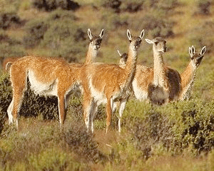
It is a long bus ride — actually several 12-hour rides, interrupted by stops in Perito Mereno, Chalten, and El Calafate. The view of vast open spaces is broken up by occasional bad roads, warning signs, scatterings of wild horses, occasional sheep and cattle ranches, and — most beautiful of all — wild guanacos on the range.
Guanacos are larger than deer and seem more powerful in the haunches. We would see them in small herds of 5-10 grazing and running on the endless ranges. The skies, too, seem to go on forever.
Endless skies in Patagonia
Early morning from the front of the bus from Barriloche to Perito Mereno. This leg of the trip was about 12 hours.
The guanacos we saw from the bus were either far away, moving quickly, or not patient enough to wait for me to find my camera, so these images are from online photos.
The animals they show are just like the lone animals and small groups we saw all across Patagonia.
We know that they were a source of food and leather for the early nomadic peoples who decorated the “Cave of the Hands” milenia ago. Guanacos continue to survive on the steppes of Patagonia, sharing the vast spaces with wild horses, and with sheep and cattle in the scattered places where there is enough water and grazing. They have some resemblance to llamas and alpacas, but are a different species.
The buses would stop about every four hours for a driver change. It was a long four hours sometimes, since the on-board toilets generally had out-of-order signs on them. The stops are unpretentious but welcome.
In this region the towns are small and widely separated, and not quite ready for a bus full of hungry, sleepy travelers. This is one of the rare daylight stops. Most stops were actually dark, surreal interludes in a long ride through rain, mixed roads, and vast spaces of land and horizon. (The actual rest stop is “pizza” place behind me, but the Codfileria here seemed more inviting.)
A stop along the way. We took a few minutes at a pizza restaurant that didn’t actually have any pizza, but did have beer and a soccer game on television.
Puerto Moreno and the Cave of the Hands
The guide referred to this as “tranquilita,” which I foolishly translated as “walk in the park.” This was offered as a more peaceful descent to the allegedly tougher main descent that used safety ropes to keep you on the mountain. Frankly, a rope would have been welcome on tranquilita.
Picking our way down “tranquilita.” One of our companions was a doctor who picked this route because, well, it sounded less risky
The goal of the tranquilita path down the mountain was the Cave of the Hands (Cueva de los Manos). It is named for the “stencils” or negative images made on the walls by nomadic peoples who used this rock face for shelter. The prints are made with mineral matter and have resisted fading or deterioration over what (the guides, and presumably the archaeologists say) has been 9000 and more years. Artifacts in the caves indicate that they lived in part from guanacos and various smaller animals in the valley. Because of the vagaries of rainfall in this region, they are believed to have been nomadic.
The Cave of the Hands (Cueva de los Manos) near Puerto Moreno is a sheltered system of rock crevices and shallow caves that extend over several hundred yards. The area overlooks a deep valley that is sometimes a river. The hand prints and occasional animal images are made of mineral matter sprayed (perhaps by mouth) to make stencils. Some date back 9,300 years, they say.
To Chalten and on to El Calafate
This road sign for bemused travelers is a reminder that we are a long way from home. New York is more than 11,000 kilometers away.
That is probably about the same as the distance to Oshkosh or Kalamazoo or Petaluma, though they don’t mention it on the sign.
One of the more exciting parts of the road from Puerto Moreno to El Calafate. The interest comes from the rare curve ahead, and the fact that it is one of the best-paved stretches of road.
Our third glacier (Perito Moreno, near El Calafate)
The Perito Moreno glacier carries the name of a town further to the north, but is reached from El Calafate at the end of our trip.
The glacial field extends some 14 kilometers between the two mountain ranges to the horizon.
The face of the glacier is about 150 feet high. It is an active ice mass — had a major rupture a few years ago, but has minor ruptures and ice slides nearly constantly. The bits of ice in front of the glacial face are pieces that have broken off. They melt slowly as they float into the lake. In the hour or two we spent watching, the glacier groaned and ruptured constantly.
“Travel writing” is a tiresome genre that is at the bottom of the creative literary ladder. One reason is that travel writing blends travelogue and personal reflection, neither of which is as useful as a good Michelin guide to restaurants and monuments. This part of my blog adheres strictly to this model of general irrelevancy, combined with personal reflection. These are a few impressions of the trip — the sort of selective view that travelers have when they have a few days and a lot of kilometers to travel. It is not a good guide to anything (except the answer to one trivia question, see below), but it has some thoughts that are specific to my own experience of Buenos (particular the architecture and culture of power). It is the first of two parts on Argentina, the second being a many-kilometer trip through Patagonia (buses, vast spaces, and glaciers).
The first 5-airport day
For people who sometimes speak of “Latinos” as a single concept, our trip from Maranhao to Argentina couldn’t have offered more insight into the poverty of this generalization. Sao Luis is on the equator and is strongly influenced by its slave history and current economic backwardness. Buenos Aires feels like a modern “European” city whose ethnic diversity is more displayed in the faces of people who are descended from the original peoples of the region (and Colombia, Peru, Chile, and Bolivia).
This was a trip from the equator to roughly the 42nd parallel south of the equator — about the same roughly distance to the south as from the equator to Chicago in the north. In other words, from the tropical center of the world to the southern regions of glaciers, snowy mountains. It is only a bit further to Tierra del Fuego where penguins look out to the water where the next stop is Antarctica.
The trip to Buenos Aires and Patagonia was a brief 10-day journey. I had to reset my Brazilian visa because I had reached the end of the number of days I could stay in one visit. As a kind of holiday present to ourselves, we spent several days in Buenos Aires, then to Barriloche (the Argentinian ski capital), and flinally by bus to Patagonia. The trip ended in El Calafate which has an airport from which we flew back through Buenos Aires to Sao Paulo, Brazil for the holidays.
We followed the famous Route 40 which links Patagonia with the rest of Argentina. It is thousands of kilometers over diverse roads — paved, unpaved, and somewhere in between.
The first day/night was a five-airport journey from Sao Luis to Brasilia to Sao Paulo (Congonhas Airport), Sao Paulo Garulhos Airport, to Buenos Aires.
The 1:30 am flight to Brasilia got us there just before dawn (photo below).
Brasilia at 6:00 am, after a night flight from Sao Luis
Brasilia, early morning skateboarder
Buenos Aires and the Change of Government
The long administration of Peronist government ended with the retirement of Christina Kirchner and the defeat of her designated successor, former Vice President Daniel Scioli, by Mauricio Macri. It was the end, at least for now, of the Peronist tradition that had been carried in recent years by Nestor, and then Christina, Kirchner. The transition was tense as Kirchner refused to attend the inauguration and gave a militant midnight speech to her supporters as she left the Casa Rosada.
This mural from rural Patagonia (Perito Mereno) shows some of the intensity of the opposition to Macri. Here he is portrayed as a pyromaniac, setting fire to Argentinian institutions and the economy
Feelings were high and the streets around the Plaza de Mayo and the Casa Rosada (the Argentinian “White House”) were a mix of excitement and tension, ratified by the presence of riot-prepared police and armored vehicles.
The Plaza de Mayo, which faces the presidential seat of government (Casa Rosada), was circled by police and tactical urban riot machinery. The previous night supporters of the outgoing Kirchner government were on the street by the thousands. The transition was quiet, however.
Riot equipment with crowd-control shields, waiting for the inauguration of Mauricio Macri as President of Argentina
Outgoing President Christina Kirchner was said to be so angry at her party’s having lost the election that there were stories (true or not) that she turned off the hot water, gave the staff a holiday, and bugged the telephones.
Maurico Macri won the presidential election in the urban areas of Buenos Aires where he attracted professionals, investors and businessmen, and younger voters. He won by only a couple of percentage points, having lost in the outlying rural regions and working class districts of Argentina (see photo above of the Macri mural in Perito Mereno)
Police ready to parade. They thwarted my candid photo when one caught sight of me and called them to order. (except for the one who was texting). Fortunately the political transition was peaceful and their duties, like their cavalry pants, were ornamental
The Plaza do Mayo is a place for demonstrations. The photo below is one of a long-standing encampment of veterans. As nearly as we could tell, their service was mainly in the Falklands War with Britain (for the islands off the Argentinian coast known as the Malvinas). This is a critical incident for the self-examination of Argentinians — they lost the war to the British, precipitating the fall of the military government. The defeat helped produce a fledgling democracy, but the veterans were lost in the dishonor of defeat.
Plaza de Mayo is also a place where the mothers and relatives of the desaparecidos — the “disappeared” — demonstrated for justice (and even just information) about those they lost during the “dirty war” of the military dictatorship (1976 to 1983). There may have been as many 30,000 lost in the government’s war against its own population, until it was forced from power following Argentina’s defeat in the Falklands War. This veterans’ camp in the plaza in front of the Casa Rosada is another sign of the unresolved recent history of Argentina’s politics.
An encampment of veterans on the Plaza Mayo, Buenos Aires
Recoleta Cemetery: Architecture of Death and Power
The Recoleta Cemetery is a city of the dead with a web of streets intersecting narrow streets lined with monuments to the wealthy and powerful dead
The families of the dead used Recoleta Cemetery to display their power and prominence,. Their gargantuan taste is another matter.
Recoleta Cemetery is a testament to the architecture of power — buildings and avenues designed to impress, show power and wealth, and remind most people that this is beyond their reach.
Parts of street life give a similar feel, but not just the beautiful Casa Rosada, the Teatro Colon, and other government, commercial and religious buildings. The very design of the city seems designed to show power.
There is a classic trivia question: “What is the widest street in the world.” Answer: In the background of the photo below — the Avenida 9 de Mayo. It is some 300 feet wide, has multiple traffic lights in crossing, and has more lanes of traffic than you count as you wend your way across.
It is a modern adaptation of an imperial road, designed to parade huge armies and horse cavalry, then soldiers, and police. If this were Russia or China it would occasionally be filled with missiles and tanks. the closest things to tanks we saw were the paramilitary vehicles at the inauguration designed to be used against its own population. A street to inhabit with power.
Buenos Aires also has scores of theaters and the legendary Teatro Colon, more or less across the Avenida 9 de Mayo where we were having coffee (photo below).
It is a marvel to cross, though that takes a while and is not without its dangers. We found our way to the other side to get to the Teatro Colon, the most famous of Buenos Aires’ hundreds of theaters. There is no street that feels like this in the world, though the streets leading to the Brandenburg Gate in Berlin has a similar feel of armies and historical power.
Imagine a street the width of two football (or soccer) fields filled with armies, tanks, politicians, rockets, and gaudy marshals on horseback. It is not so long ago this power in Argentina has a military dictatorship “disappeared” thousands of citizens, still without a trace.
Buenos Aires has cafes built on an angle on many intersections. The foot and automobile traffic gives the sense of a kaleidoscope surrounding you on three sides. The street in the background is the Avenida 9 de May, and is the widest of any city in the world.
This man with a cart of boxes (photo below) is incongruously pulling it across the widest street in the world.
Crossing the Avenida 9 de May, Buenos Aires
This building is currently an alternative medicine/pharmacy store, but its architecture is astounding for a commercial building. It is on a shopping street that is lined with buildings that look like the old downtown of Madrid. The question might be: “Who needs such a building?” But the answer is in the sheer beauty of its excess.
Puerto Madera
The old area of working docks has been refurbished as a tourist district with office and commercial buildings, and a wealth of restaurants.
The ship below was once used to supply Antarctic explorers. Photographs nearby show its sister ship sinking in the Antarctic ice. It was a reminder of how close the tip of Argentina is to the end of Latin America. I think Sidney, Australia is closer to this dock than Chicago.
Puerto Madero, and area of former working docks. This ship was once an Antarctic freighter and is now a display boat for visitors (to look at while they eat in the district’s remarkable restaurants).
Parts of Puerto Madero resemble London’s Canary Wharf development with sleek buildings and modern businesses set in a former working dock
A rare opportunity: One of Simone’s former artistic directors and choreographers
Buenos Aires is full of tango clubs, tango lessons, tango shows, and touts on the street who can take you to one or another. The shows are famous, but we found something much better. Oscar Araiz was the artistic director of the Geneva Grand Theatre when Simone danced there. He is now semi-retired in Buenos Aires. When we visited him he was recreating one of his classic works, “Tango,” in which Simone danced some years ago in Geneva. He was still exceptionally creative and developing a new work with several young professional male dances and an unusual vocal score by Mahler.
We spent an evening with Oscar and sat in on his rehearsal the following day. It was held at the University of San Martin on the outskirts of Buenos Aires.